| View previous topic :: View next topic |
| Author |
Message |
Stefan
Banned

Joined: 29 Aug 2006
Posts: 1219
|
 Posted: Thu Mar 08, 2007 5:40 pm Post subject: Flight path/azimuth details - help please Posted: Thu Mar 08, 2007 5:40 pm Post subject: Flight path/azimuth details - help please |
 |
|
Hi Snowygrouch, JohnDoeX,
I have been hitting political forums with your new research and generally it has left people cynical of the existence of bare faced lies in the official story red faced and unable to respond in any way, except the standard insults, and, most positivley a few people who have opposed my views for a long time admitting there are some serious questions there.
However one poster has distinguished them self by asking some mature and well phrased questions. Could you help me out with the answers?
“I would like to ask some questions about the data that is presented by your videos. There are a couple of discrepencies.Bear with me, It will take a moment to explain this.It takes a comparison of the 2 videos, or the information provided by the flight path simulation.
Using the video you have labelled "witnesses" at time index 0:07 tells us that this is "CITGO eyewitness POV from the North side of the station" and at time index 0:13, they show us the citgo station and show us the position of the eyewitness(es) relative to the Citgo station, on the north side of the Citgo station.
At time index 1:31 we can see the shape of the citgo station and their proposed flight path(that of the Citgo eyewitness) and the official flight path. Look closely at this at index 1:31. Notice that the Norh side of the Citgo is the short leg of the rectangle closest to the "CITGO eyewitness flight path". Therefore the long leg of the rectangle closest to the pentagon faces east. Notice that, the proposed "Citgo eyewitness flight path" . Now notice that this east face of the Citgo station makes an acute angle with the "Citgo eyewitness flight path".(if you were to draw a line along the east face of the Citgo and extend it down to the "Citgo proposed flight path" you will see the acute angle which looks to be about 60 degrees relative to that extended line.
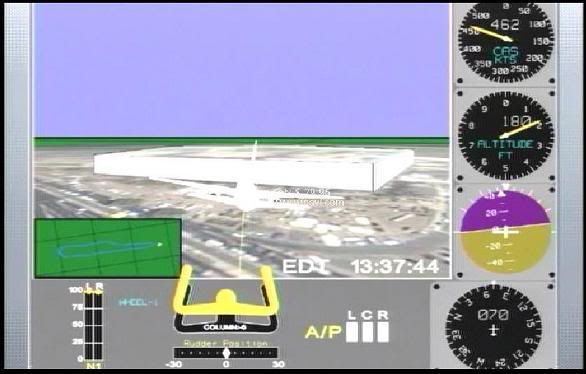
Using your other link which is labelled "black box data", that claims to be from pilotsfor 911truth.org. What I have not found ther yet (and perhaps you can identify it) is the same as what is shown at at http://pilotsfor911truth.org/pentagon.html, the instrument readings of the aircraft "in the last second of data" (just before impact). looking at the first simulation pic on the site, the aircraft would appear to be just about over the Citgo, at about the same place as referenced above at Time Index 1:31. We note the following from the aircraft instruments just before impact (which is officially reported as EDT 9:37:45);
Note the time 13:37:44 (shown in the simulation as EDT, but clearly that is GMT)
Air speed 462, Altitude 180 (ft), Azimuth - banked left Heading 070 (ENE).
Take note of the following ;
- The heading is 070(ENE) . Compare that to the flight path and Citgo at time index 1:31. This is not consistent with the heading of 070.. The proposed CITgo flight path would be a heading of about 100 or 110 ESE to SE. In fact, the heading of 070 is closer to the "official" flight path (but not exact).
- Azimuth shows the aitcraft is banking left, that is tilted with the left side down. This is consistent with a slight left turn (towards the NE. given the heading of 070)...(now this makes it somewhat more consistent with the official flight path.with just a few degrees of left turning)
Consider that, if the aircraft wee just to the north of the Citgo, with a heading of 070. it would miss the Pentagon. It should be heading ESE or SE to hit the pentagon. The fact that it is banked left also suggests that it would be turning away from the Pentagon. The line shown as the "Citgo eyewitness flight path" would have to be an ESE to SE course.(100-120)
Can you explain this ? It looks like a fairly major discrepency.
Other questions:
- The report on the "witness" video of the plane "pulling up" to avoid the lamp posts. I thought it was nowhere near the lamp posts and I don't see how the aircraft could have "pulled up" anyway given a downward trajectory and his air speed. But that depends on how much flap he had out, which is not reported and the distance from Citgo /lamp posts to the impact area.
- The altimeter data. Altimeters can be off +/- 75 feet (he does report that on his site) and the correction he listed. I was under hte impression that modern altimeters like those on commercial aircraft corrected based on digital data broadcasted from nearby weather beacons as determined by GPS position data. But I'm not certain is if that corrected reading or the raw altimeter data is fed to the flight data recorder.
- Commercial aircraft have been capturing and using GPS position data for the past 15 years ? Is it included on the AA77 flight data recorder ? (it was for TWA flight 800 so why not AA77 ? )”
A response would be great- it’s so rare on internet forums for people who still believe the Official Conspiracy Theory to ask real questions rather than hurl mud or employ straw men. I’d love to respond to him/her with the same level of respect and know I don’t have the knowledge to answer (or even totally understand) the questions posed.
Thanks guys!
_________________

Peace and Truth |
|
| Back to top |
|
 |
Snowygrouch
Validated Poster


Joined: 02 Apr 2006
Posts: 628
Location: Oxford
|
| Posted: Thu Mar 08, 2007 6:31 pm Post subject: |
|
|
1: We have radio altitiude from the raw FDR file and this correlates almost exactly with the pressure alt. Radio alt is far more accurate than pressure alt.
2: The plane could never have banked at that speed, its going 200m/s at that point.
3: The light poles are knocked over in a straight line, a path NORTH of CITGO CANNOT POSSIBLY have hit even one of those poles.
4: We know the errors are far more than those commonly occuring in FDRs due to instrument error or other misc recording "noise".
5: We know from conversations with FDR industry experts that solid state recorders cannot have their flightpath "altered" due to crash damage. There are too many variables to be able to intelligently alter binary to a different path.
6: The VOR DME of 1.5 nautical miles as a final data point from the raw data positions the plane where the animation shows (north of Citgo).
7: All the mag heading and true heading stuff is in the raw FDR files which we have. We know exactly where the plane was really heading.
8: None of the recoding parameters show the plane in any final position to level off where the damage to the poles and a final skim across the Pent lawn would require. The plane according to all the FDR parameters never came close to levelling off.
9: According to the FDR the plane never went below 273 feet above GROUND level (from rad alt) at VOR of 1.5 NM from Regan national DME beacon.
For more detailed stuff you`ll have to contact Rob or Chris at PFT.
Cheerio
Calum
_________________
The potential for the disastrous rise of misplaced power exists, and will persist
President Eisenhower 1961 |
|
| Back to top |
|
|
SHERITON HOTEL
Moderate Poster

Joined: 18 Jun 2006
Posts: 988
|
| Posted: Thu Mar 08, 2007 6:48 pm Post subject: |
|
|
| You'd think someone asking such technical questions from a 'well informed/knows his-her subject' background could see there was no 757 crashing into that obscure side of the Pentagon from the CCTV film the organisation 'Judicial watch' wormed out of the US government after 5 years under FOI and that the Pentagon changing their original story that there was no CCTV pentagon security footage of the 757 9/11 and the FBI confiscating all that local private business and freeway camera film of the "attack" amount to clear guilty demeanour! |
|
| Back to top |
|
|
johndoex
Minor Poster

Joined: 17 Aug 2006
Posts: 87
|
| Posted: Fri Mar 09, 2007 7:47 am Post subject: Re: FAO Snowygrouch, John DoeX or anyone else who can help. |
|
|
| Stefan wrote: | Hi Snowygrouch, JohnDoeX,
- Azimuth shows the aitcraft is banking left, that is tilted with the left side down. This is consistent with a slight left turn (towards the NE. given the heading of 070)...(now this makes it somewhat more consistent with the official flight path.with just a few degrees of left turning)
! |
um... this looks like a right bank to me... perhaps your friend has dyslexia?
Go to this link to find out how the headings/flight path was altered in the csv file to match the southern approach...
http://z9.invisionfree.com/Pilots_For_Truth/index.php?showtopic=5083
Calum pretty much handled the rest...
Cheers!
Rob
_________________
www.pilotsfor911truth.org
www.pilotsfor911truth.org/forum |
|
| Back to top |
|
|
physicist
Moderate Poster

Joined: 09 Jun 2006
Posts: 170
Location: zz
|
| Posted: Fri Mar 09, 2007 9:28 am Post subject: Re: FAO Snowygrouch, John DoeX or anyone else who can help. |
|
|
| Stefan wrote: | At time index 1:31 we can see the shape of the citgo station and their proposed flight path(that of the Citgo eyewitness) and the official flight path. Look closely at this at index 1:31. Notice that the Norh side of the Citgo is the short leg of the rectangle closest to the "CITGO eyewitness flight path". Therefore the long leg of the rectangle closest to the pentagon faces east. Notice that, the proposed "Citgo eyewitness flight path" . Now notice that this east face of the Citgo station makes an acute angle with the "Citgo eyewitness flight path".(if you were to draw a line along the east face of the Citgo and extend it down to the "Citgo proposed flight path" you will see the acute angle which looks to be about 60 degrees relative to that extended line.
Using your other link which is labelled "black box data", that claims to be from pilotsfor 911truth.org. What I have not found ther yet (and perhaps you can identify it) is the same as what is shown at at http://pilotsfor911truth.org/pentagon.html, the instrument readings of the aircraft "in the last second of data" (just before impact). looking at the first simulation pic on the site, the aircraft would appear to be just about over the Citgo, at about the same place as referenced above at Time Index 1:31. We note the following from the aircraft instruments just before impact (which is officially reported as EDT 9:37:45);
Note the time 13:37:44 (shown in the simulation as EDT, but clearly that is GMT)
Air speed 462, Altitude 180 (ft), Azimuth - banked left Heading 070 (ENE).
Take note of the following ;
- The heading is 070(ENE) . Compare that to the flight path and Citgo at time index 1:31. This is not consistent with the heading of 070.. The proposed CITgo flight path would be a heading of about 100 or 110 ESE to SE. In fact, the heading of 070 is closer to the "official" flight path (but not exact).
- Azimuth shows the aitcraft is banking left, that is tilted with the left side down. This is consistent with a slight left turn (towards the NE. given the heading of 070)...(now this makes it somewhat more consistent with the official flight path.with just a few degrees of left turning)
Consider that, if the aircraft wee just to the north of the Citgo, with a heading of 070. it would miss the Pentagon. It should be heading ESE or SE to hit the pentagon. The fact that it is banked left also suggests that it would be turning away from the Pentagon. The line shown as the "Citgo eyewitness flight path" would have to be an ESE to SE course.(100-120)
|
The "short leg" of the rectangle of the Citgo gas station does not face north. It's at an angle.
 |
|
| Back to top |
|
|
Micpsi
Moderate Poster
Joined: 13 Feb 2007
Posts: 505
|
| Posted: Mon Mar 12, 2007 12:01 am Post subject: |
|
|
| Um, yes. But the witnesses were at the 'north end' of the Citgo. I think we all understand what that means, even though this end was not facing north precisely. |
|
| Back to top |
|
|
|